
Introduction
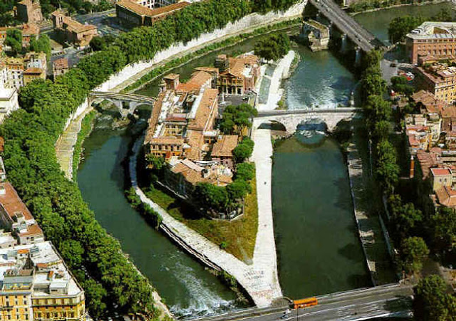
Since the founding of Rome, the Tiber River has been integral to the development of the Eternal City. The citizens of Rome and the river have a complex relationship, and nothing symbolizes that relationship better than the Tiber Island. Today, Tiber Island sits in the middle of the Tiber River in the heart of Rome, just east of the Roman Forum. Atop the island are several buildings including a hospital and lining the island and the surrounding riverbanks are majestic travertine embankments. However, as with most things in Rome, the story of how the island and river’s current state came to be is anything but simple. Evidence shows that the island has not always existed, and generations of Romans have worked to engineer the island and the river to protect themselves from dangerous floods (Brock et al. 2026). Therefore, it is worth investigating what led to the formation of Tiber Island, and how did successive engineering modifications to the island and surrounding riverbanks affect the areas resistance to flooding?
A variety of theories for the origin of Tiber Island have been presented over time; however, the most likely case is that a variety of factors contributed to its formation with human deforestation being a primary one. Several generations of engineering works have protected the island, however insufficient engineering has also led to the failure of infrastructure worth investigating, specifically the overturning of a riverbank embankment in 1900.
Formation of Tiber Island
Until recently, it was not confirmed that Tiber Island had formed in recent geological history. Many early scholars and historians believed that the island significantly predated the settlement of Rome (Brock et al., 2026). Interestingly, ancient Roman sources recount the formation of the island, however they are closer to legends than accurate historical records. One common story recounted by Brock et al. (2026) is that in 509 BCE, King Tarquinius Superbus was ousted from his rule and to atone for his religious transgressions the people dumped his crops in the river. Due to low mid-summer flow of the river, the crops did not wash away and instead accumulated. This led to the compounding of other sentiments and eventually created the island that is known today. However, questions about the validity of this story, particularly the fact that the island is known to have existed prior to this date, have led scholars to consider this as myth over fact (Brock et al., 2026).
Early scholars discarding these legends instead believed that the island was a permanent feature of the landscape (Brock et al., 2026). From personal observation visiting the island today, it is easy to understand why this was assumed as the island is very well established and integrated into the Tiber landscape. The leading theory was that the island was comprised of volcanic tuff similar to the major hills of Rome. This was evidenced by French historian Maurice Besnier’s 1902 study of the island during which he received information from engineers of adjacent bridge Ponte Cestio that they had uncovered volcanic materials under a layer of sand silt and gravel (Brock et al., 2026). However, this study was far from comprehensive and relied on flawed assumptions. The information was passed through word of mouth, no information on the composition of the volcanic material (whether it was solid bedrock or simply fragments) was recorded, and investigation into how deep the volcanic material went was not conducted (Brock et al., 2026).
Beginning in the mid twentieth century, scholars began questioning the assumption that the island was volcanic bedrock in composition. Repeated geological studies proposed that the island was instead comprised of alluvial sentiments, and this came to become the predominantly accepted theory (Marra et al., 2018). However, it was not until quite recently that direct investigations including core sampling were allowed to be conducted due to the historical and infrastructural importance of the island.
A study published in 2026 by Andrea Brock, Laura Motta, and Nicola Terrenato was given permission to drill a 23.6 meter deep core sample on Tiber Island. Investigation of the sample confirmed the theory that the island formed through sedimentation and reviled numerous details about the process. Earlier research had theorized that prior to the sixth century, the area of Tiber Island was an ephemeral river bar (Marra et al., 2025). During periods of low water this bar would have periodically been exposed, and during periods of high water the bar would grow in size due to sedimentation, until a flood would erode the bar and repeat the process (Marra et al., 2025). The core sample taken confirmed this theory, and also confirmed that beginning in the sixth century BCE, over the course of approximately one hundred years, the area that is now Tiber Island gained 4-6 meters of height through sediment deposits (Brock et al. 2026).
Reasons for Rapid Sedimentation During the Sixth Century BCE
A few reasons for this rapid growth have been proposed. Core samples from other areas along the Tiber River show evidence of the same sedimentation event in the sixth century BCE, so the cause must have been a wider regional event as opposed to a localized one (Brock et al. 2026). One possible reason is a sustained increase in precipitation in the area leading to increased erosion and runoff. Typical year-to-year fluctuations alone would not be enough to cause such a significant impact, only a long-term shift in climate could. Indeed, there is evidence of fluctuations between periods of heightened and lowered precipitation levels from cave mineral deposits in northern Italy, including in a few century long period of heightened precipitation around the sixth century BCE (Marra et al. 2018). However, the lack of precision and distance of these sites from Rome mean a specific period of heightened perception capable of causing the sedimentation that formed Tiber Island cannot be proven.
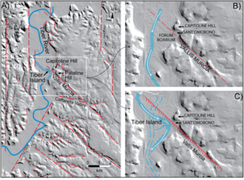
Another theory is that the tectonic setting of the area could have spurred the event. Rome is known to have several minor faults in and around the city and according to Fabrizio Marra et al. (2018) evidence indicates the possibility of a NW-SE fault line that runs adjacent to Tiber Island (Figure 2). They propose that tectonic activity originating from this strike-slip fault could have led to a change in topography in the past that may have altered the course of the river, and activity could have led to a small change in elevation on one side of the fault creating a small step in the river, a fault scarp. This step would have reduced the velocity of the river and increasing deposition of settlement around the ledge, triggering the buildup of the sentiment that became Tiber Island. While this theory is certainly a plausible explanation for the localized sedimentation that created Tiber Island, it fails to explain the wider sedimentation throughout the Tiber River floodplain suggesting that this was likely not the only contributing factor.
The final major theory proposed by Brock et al. (2026) is that human driven deforestation led to elevated levels of erosion and thus sediment in the Tiber River. The sixth century coincides with a period of rapid human settlement in Rome and wider central Italy. As humans transitioned from small villages and huts to large cities, large scale construction exploded. This construction required a significant increase in building material collection including building stones and timber. Dust and material produced as a side product of quarrying near the river could have contributed to an increase in material, however deforestation likely had a much greater impact. The increase in construction activity required immense amounts of timber, for timber frames and structures and also as fuel for kilns that fired terracotta roof tiles. Deforestation around the river would have led to the destabilization of slopes and a massive increase of erosion during periods of heavy precipitation (Brock et al. 2026). Additionally, as learned on a tour of the Pacifici Cava travertine quarry, quarries near the river were desirable because it was by far the easiest way to transport material into Rome, so it follows that areas immediately adjacent to the river and upriver from Rome would have been the most desirable areas for timber harvest for the same reason.
While deforestation spurred by human urbanization seems to be the most likely and supportable reason for the rapid sedimentation that created Tiber Island, there is not enough evidence to definitively say that this was the primary or only factor. It is quite possible, if not probable, that a combination of these factors and possibly others all contributed to the rapid four-to-six-meter increase in elevation of the river bar that became Tiber Island. To conclusively determine the cause, more investigation is necessary.
Human Development on and Around the Island
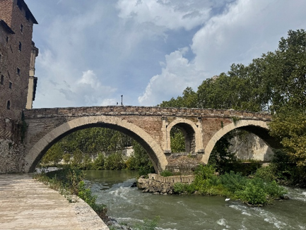
Even before the formation of the island, the area was extremely valuable to early Roman settlers as the shallow river bar and slow current provided an easy and safe point to ford the river (Brock et al., 2021). From personal observation, the stretches of river right before and after the island are some of the widest parts of the river and have some of the slowest currents. As the city developed and the island formed, infrastructure was built on the island, and a timber bridge was built over the Tiber River immediately south of the island. Later the Timber Bridge was replaced by the Pons Aemilius, completed in 142 BCE, the first stone bridge crossing the Tiber (Brock et al., 2021). The first stone bridge built between Tiber Island and the mainland, the Pons Fabricius, was built in 62 BCE (Brock et al., 2021) (Figure 3). It is the oldest bridge still in its original form still in use in Rome (Brock et al., 2021). As a pedestrian it can still used to get to the island, however it apears to be too narrow to be used by vehicle traffic, reflective of the time it was built. Through observation one can see the stonework is quite weathered.
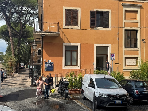
The first recorded permanent structure on the island came in 291 BCE spurred by an event which has shaped the identity of the island. As detailed by Valenzano et al. (2024), legend goes that in 293 BCE, a severe plague hit Rome, and a ship was sent to Epidaurus in Greece to secure the blessing of Aesculapius, the god of medicine and healing. When the ship returned a serpent representing the god is said to have slithered onto the island, marking it as a sacred area for healing. Thus, the Temple of Aesculapius was created on the island to honor the god (Valenzano et al., 2024). The island’s identity as a place of healing has remained ever since. Around 1000 CE the temple was replaced by a religious sanctuary that provided help and shelter for beggars, the poor, and the sick (Valenzano et al., 2024). In 1585 CE a hospital was established on the island that had particular importance during World War Two as it was used to protect Jewish people from the Nazis with the creation of a fake disease “K Syndrome” (Valenzano et al., 2024). The hospital still exists to this day, and one can personally see its several entrances and watch ambulances approaching from over the bridge (Figure 4).
Historical Flood Protection Efforts
The ancient Roman construction of infrastructure on island including the Temple of Aesculapius likely served to stabilize the island from the beginning, reducing erosion and runoff during flood events. The first significant flood defense for the island was constructed in the first century BCE. According to Chiavoni et al. (2023), to commemorate the ship which brought the serpent of Aesculapius, the banks of the island were incased in stone with each end of the island resembling the prow and stern of a ship. An obelisk was also built in the center of the island resembling a mast. Chiavoni et al. (2023) explains that the exterior of the structure was comprised of travertine blocks with peperino elements, and tuff walls existed behind the travertine. The shape of the island and travertine sculpting led the island to be referred to as the “stone ship” (Figures 5 & 6).
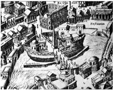
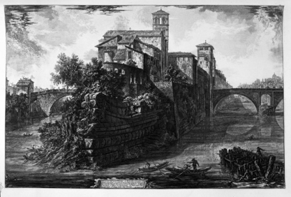
While the stone ship design was symbolic, it also had many practical benefits to the island, although it is unknown to what extent these benefits were intentional. It permanently established the perimeter of the island and served to protect the island from the forces of the river (Chiavoni et al., 2023). The travertine blocks took advantage of the natural ship-like shape of the island to reinforce the banks and ends of the island (Chiavoni et al., 2023). Illustrations of the stone ship suggest that the travertine and tuff walls acted as retaining walls for the island and supported building construction atop the island (Guarneri & Nisio, 2021). The walls would have resisted scouring and prevented lateral erosion, especially during high flow periods (Guarneri & Nisio, 2021).
Unfortunately, not much documentation of the stone ship exists beyond several illustrations. The exact dimensions and properties of the stone ship are not known so a comprehensive analysis into the flood resistance effects or retaining wall properties of the structure is not possible. The only remaining physical evidence of the stone ship is a section of the original travertine wall and façade on the eastern, down river end of the island (Figure 7).
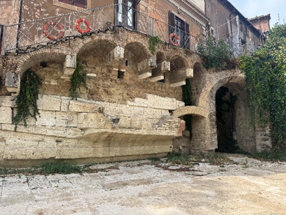
By visiting the remaining element, it does appear support the idea that the stone ship acted as a retaining wall for the island as it forms the base for the present day building on top. If it were to incase the whole island as it once did, it would certainly protect the island from floodwaters.
Until the modern era, the riverbanks adjacent to Tiber Island had no significant flood protection infrastructure. The banks were mostly vegetated slopes with ports and bridges in places, and when the Tiber River reached flood levels areas of the city would become inundated, a recurring problem.
Modern Flood Control for the Tiber Island and Surrounding Area
In December 1870, a major flood of 17.22 meters above zero inundating roughly half of the city (Valenti, 2025). While this flood was one of the larger ones to impact Rome in recorded history, it was far from unusual, and the citizens of Rome were accustomed to regular seasonal flooding of the city (Valenti, 2025). The nature of flooding of the Tiber up to this point was more of a slow expansion of the river, not a torrential flash flood. Thus, while the floods such as the 1870 flood were damaging, they weren’t catastrophic, and no fatalities occurred in 1870 (Valenti, 2025). However, Rome had just been captured by Italian reunification forces and the King intended to make Rome the new capital of Italy. This led the new Roman leadership to establish a commission tasked with controlling the river and preventing future floods all together (Valenti, 2025). Several proposals were considered including a plan to build a bypass channel to increase the rivers capacity through the historic center of Rome, and a plan to completely divert the river around Rome (Casini et al., 2022). Ultimately, a proposal by engineer Raffaele Canevari to regularize the river through Rome was selected. His plan called to remove several ports along the river, dredge and clear the riverbed of ancient ruins and debris and widen the river to a standardized 100 meters (Valenti, 2025). The most significant part of his plan was to build massive near vertical travertine embankments along a 4.5 kilometer stretch of the river through Rome. These floodwalls were called the “Muraglioni.” Atop the embankments would be two large boulevards, and under the boulevards would be sewage tunnels (Casini et al., 2022).
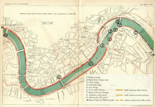
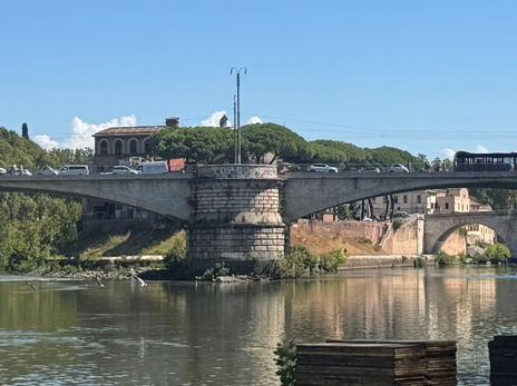
For Tiber Island, the plan initially called for filling in the channel along the north shore of the island, connecting the island to the mainland (Casini et al., 2022) (Figure 8). Through personal observation, the north channel does appear to be a bit narrower and certainly is less straight, so this would have been a logical solution from an engineering point of view. However, the southern channel doesn’t look to be wide enough to accommodate the regularized river width so this likely would have required the demolition of some structures either on the south bank or Tiber Island. The plan was eventually revised and both channels were kept, the right one to be 70 meters and the left one 60 meters. The Ponte Garibaldi would be a new bridge spanning the river immediately upstream of the island, and its central support column would double as the head of the flood defense structure protecting Tiber Island (Figure 9). Sloping embankments and retaining walls would wrap around the island and protect it during floods (Casini et al., 2022). All of these elements can be viewed today, and a staircase on the south side of Tiber Island provides an access point to walk around the island on the quays and view the embankments up close. Dredging of the river and construction on the Muraglioni began in 1875 (Valenti, 2025).
The Flood of 1900 and Embankment Collapse
By 1900, the Muraglioni through central Rome had mostly been completed, including the fortification of the Tiber Island (Casini et al., 2022). In December of that year, a major flood peaking at 16.17 meters above zero tested the new flood control system (Casini et al., 2022). The island itself resisted major damage, and the Muraglioni largely prevented the city from flooding, however, as the floodwaters receded a 110-meter long stretch of the wall immediately adjacent to Tiber Island collapsed (Valenti, 2025) (Figure 10). This collapse can be directly attributed to modifications made to Tiber Island for flood control combined with insufficient engineering of the flood walls (Associazione Isola Tiberina, n.d.) (Casini et al., 2022).
Fortunately, this incident was thoroughly documented. A commission created in 1901 led by Luigi Cremona was tasked with investigating and determining the cause of failure providing much of the detailed specifications available today. An analysis into the failure done by F. Casini, A. Pucci, I. Giannetti and G. Guida (2022) provides an excellent English translation of the knowledge presented in the report and a modern analysis into the failure.
Embankment Failure Analysis
The Muraglioni floodwalls essentially act as large gravity retaining walls, as they have no anchors or reinforcing steel. The primary structure of the walls is tuff blocks joined with pozzolanic mortar and clad with travertine (Casini et al., 2022). The foundations were constructed using large iron caissons, first sunken in the riverbank and pumped full of compressed air, then filled with concrete (Casini et al., 2022). This gives the structure three primary possible modes of failure: sliding, overturing, and bearing capacity failure. The 1901 report led by Cremona reported that the cause of failure for the wall was definitively and solely overturing due to scouring under the foundation during the flood (Casini et al., 2022). Casini et al. calculates the moments and forces experienced by the wall at various points during the flood to determine the mode of failure and comes to the same conclusion. The study explains its basic methodology; however, it does not include its calculations. It does however include the values used for dimensions and properties of the wall and surrounding soil, either taken directly from Cremona’s 1901 report or estimated with reasonable assumptions (Casini et al., 2022). Thus, a study into the forces that led to the overturning of the wall is possible.
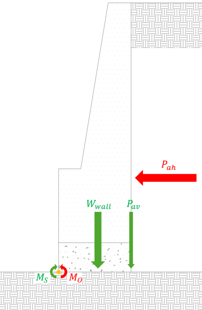
The soil backfill exerts horizontal active earth pressure () on the wall which is attempting to overturn it. This can be modeled as a moment around the riverside toe of the foundation (). This moment is resisted by the weight of the wall () and the vertical component of active earth pressure from the backfill (), which can also be modeled as a moment () (Figure 11). During normal conditions, the water of the river does not have a significant effect on the wall, since groundwater on the backfill side is at the same level and thus cancels out the force. However, when river level rises or lowers rapidly, the groundwater level does not keep up, so water on one side of the wall or the other could contribute to the stabilizing or overturing forces. By comparing the overturning moment to the stabilizing moment, it can be determined how close the wall was to failure before the flood.
Stabilizing Moment
The stabilizing moment can be modeled as so:
Where:
= stabilizing moment (kN
m)
= weight of the wall (kN)
= moment arm for (m)
= vertical component of active earth pressure (kN)
= moment arm for (m)
The dimensions of the wall are shown in Figure 12. All dimensions were taken from Casini et al., 2022. For this investigation, a 1-meter length of the wall will be analyzed.
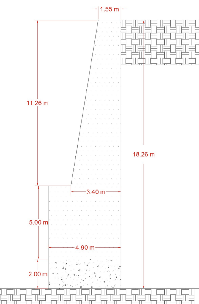
To find the weight and moment arm of the wall, it can be split into three pieces with associated horizontal moment arms from the river side toe of the wall (Figure 13).
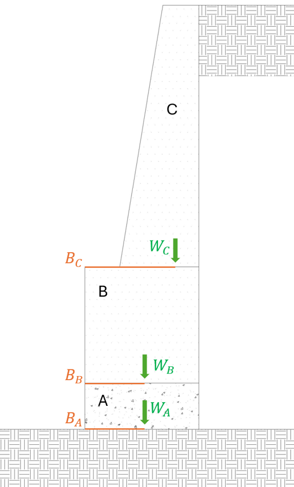
The weight of each piece for a 1-meter length of wall is as follows. The density of concrete (piece A) from this period was roughly 2100 (Ambroziak & Haustien, 2022). The average density of tuff and mortar stonework (pieces B and C) in similar structures is approximately 1750 (Jackson et al., 2009).
The horizontal moment arm for rectangles A and B is half of their width: 4.90 meters divided by 2 which is 2.45 meters. The horizontal moment arm for piece C can be found by dividing the sub piece into a rectangle and a triangle, finding the moment arm of each, and finding the weighted average of the two values. This yields a moment arm of 3.60 meters.
So, the total stabilizing moment from the weight of the wall can be found by adding the moment of each section.
To find the vertical competent of active earth pressure, the equation for active earth pressure based on Coulomb’s Theory can be used. 
Where:
= active earth pressure per unit length of the wall (kN/m)
= unit weight of the backfill soil ()
= height of the retaining wall (m)
= coefficient of active earth pressure
The Casini et al. (2022) study includes several properties of the soil backfill including a unit weight of 16 and an active earth coefficient of 0.27, and from this a calculated vertical active earth coefficient of 0.101 and horizontal active earth coefficient of 0.25. So, the vertical component of active earth pressure per unit length of wall, , can be calculated like so.
For a one-meter length of wall, is 269.4 kN. Since this force is exerted on the backfill edge of the floodwall, its moment arm, , is equal to the distance from backfill edge to the riverside toe of the wall, or the width of base, 4.90 meters. The stabilizing moment of the vertical component of active earth pressure is as follows:
So, the total stabilizing moment can be found by adding the two stabilizing moments.
Overturning Moment
The overturing moment comes from the horizontal component of active earth pressure from the backfill. This can be found using the same method as the vertical component but replacing the vertical active earth coefficient with the horizontal one.
So, for a one-meter length of wall, the backfill exerts 666.9 kN. Since the relationship between depth and pressure is linear, the pressure can be modeled as a triangle. Thus, the vertical moment arm from the toe of the wall, , is equal to one third the height of the wall, or 18.26/3 which is equal to 6.086 meters (Figure 14).
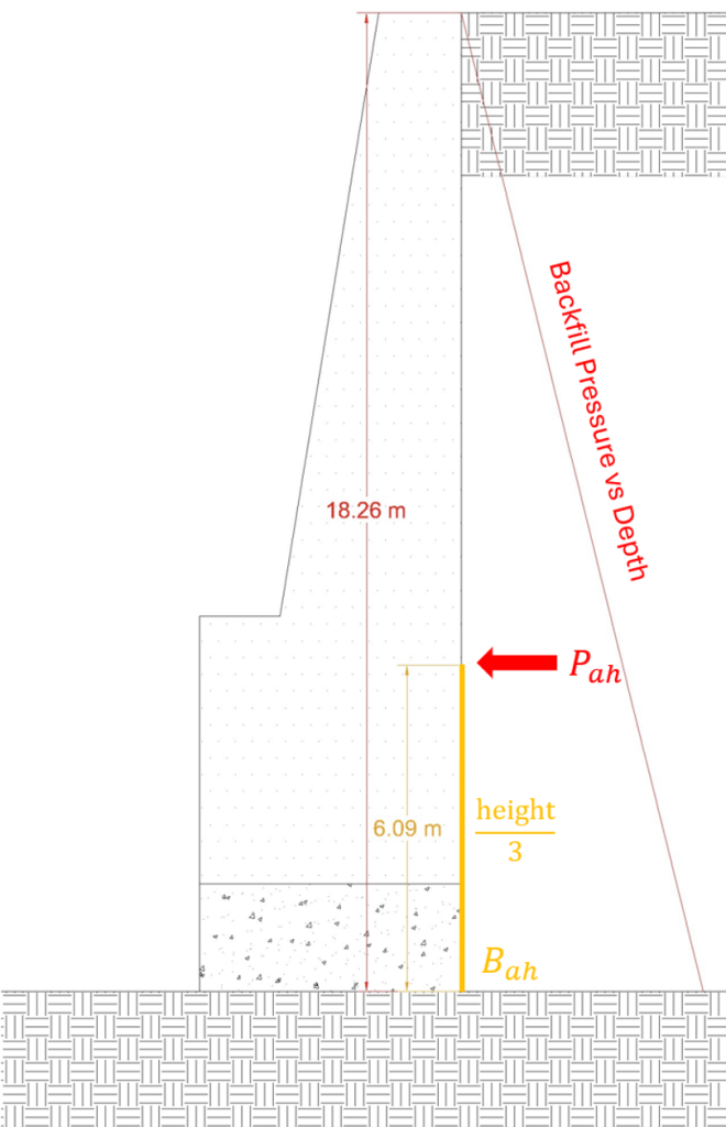
So, the overturing moment, , can be calculated as such:
Factor of Safety
Before the flood, the stabilizing moment was 4567 kNm and the overturing moment was 4059 kNm. The factor of safety can be found by dividing the stabilizing moment by the overturing moment.
The factor of safety of 1.13 is quite small, indicating that the embankment was not far from failure even during normal conditions. This agrees with the conclusion reached by the Casini et al. study (2022). In reality, this is an oversimplification of the problem. Other factors were affecting the embankment such as foundation uplift from porous pressure which Casini et al. (2022) considers, however this calculation provides a good estimate for the moments and factor of safety.
Collapse
On December 2nd, 1900, at 2 pm the flood hit a peak water level of 16.17 meters above zero (Casini et al. 2022). The entire flood had a capacity of 4200 , one of the largest floods by capacity to hit Rome during modern history (Casini et al. 2022). The Casini et al. (2022) study estimated that scouring under the part of the embankment that collapsed was 1.7 meters deep and 0.8 meters in-set from the toe of the foundation. This significantly destabilized the wall. During the peak of the flood, the high water exerted a stabilizing pressure on the floodwall opposite the lateral pressure exerted by the backfill. This allowed the floodwall to remain standing during the peak of the flood (Casini et al. 2022). However, as the water receded, this stabilizing pressure waned. Additionally, it is likely the overturing pressure of the backfill increased due to water seepage behind the embankment (Casini et al. 2022).
At roughly 10:30 am on December 4th, a 110-meter section embankment immediately adjacent to Tiber Island on the south side of the river collapsed into the river (Casini et al. 2022). At this point, the river had fallen to approximately 9.25 meters above zero, only 3 meters above normal levels (Casini et al. 2022). Because the factor of safety for the overturing of the embankment was minimal, scouring under the foundation and possible seepage behind the wall caused it to overturn (Casini et al. 2022).
However, the entire 4.5 km length of the Muraglioni was built to the same specifications which raises the question why only this section failed. The answer lies with Tiber Island. The unequal channel widths on either side of the island combined with the geometry of the Ponte Garibaldi support which serves as the head of the island funneled water unevenly towards the south channel both before the flood and during the flood (Associazione Isola Tiberina, n.d.). Because of the uneven flow, the north channel experienced increased sedimentation before the flood which farther increased the flow in the south channel during the flood (Associazione Isola Tiberina, n.d.). These factors likely lead to the section of embankment immediately south of Tiber Island experiencing the strongest flood flow rate of anywhere along the Muraglioni, leading to more severe scouring and ultimately failure.
Floodwall Repair and Improvement
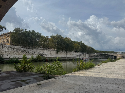
To prevent the failure from repeating itself, several improvements were made to the design of the Muraglioni and implemented along the entire stretch of the river. First, the thickness of the wall which collapsed was widened to increase its weight, and measures to improve drainage of the backfill were implemented (Giannetti & Casini, 2022). Then 8- to 15-meter wide quays were built along the entire length of the Muraglioni to a height above the typical non flood stage level of the river (Figure 15). These quays can be accessed today, and the quays on one side of the river have an excellent bike path giving the infrastructure an additional public benefit. Finally, riprap was placed along the base of the quays to prevent scouring under the quays (Giannetti & Casini, 2022) (Figure 16). Together these measures effectively protect the floodwall foundations from being undermined through scouring, preventing a similar failure to that of 1900 from occurring.
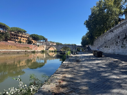
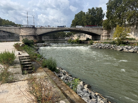
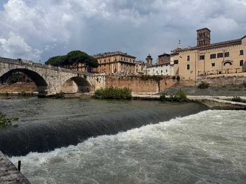
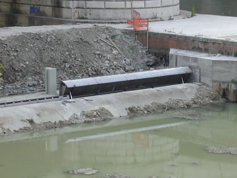
Modifications were also made to the geometry of the channels on either side of Tiber Island. The left side which had experienced sediment buildup was dredged, and in the right channel a large sill was built under near Ponte Cestio to rebalance the flow between the two channels (Associazione Isola Tiberina, n.d.) (Figure 17). In more recent years, a more complex engineering project was completed to moderate the flow in each channel for different water levels ensuring an even distribution. The fixed sills were replaced with ones of variable height in 2003, allowing engineers to adjust their height and thus their effect on the river for different river flow levels (Associazione Isola Tiberina, n.d.) (Figure 16 & 18). Today, walkiing along the riverbank or on Tiber Island the turbulance from both the large sill in the south channel and the variable height sills can be observed, and the river current before the sills is noticably slower.
Conclusion
The Tiber River, Tiber Island, and the Romans have been inextricably connected to each other for over two and a half millennia through legend, health, flooding, and engineering, and each has impacted the other in profound ways. The reason for the formation of the island cannot be definitively confirmed, and a combination of factors is most likely with deforestation driven by human settlement likely playing a crucial role. Since its formation, Tiber Island has been important to ancient Rome both in a practical sense as a crossing point and mythological sense as a place of healing. Romans have successively modified the island and surrounding river in an attempt to protect it and prevent damaging floods. They’ve achieved success; however, the river and island have also interacted in ways that set them back, the overturing of a section of embankment during the flood of 1900 due in part to insufficient engineering. Subsequent improvements and modern projects have addressed this issue have successfully countered the threat of floods to Rome since. Investigating the origins of Tiber Island and how human engineering of the island and river have succeeded and failed provides valuable insight into how engineering has helped make Rome the Eternal City and can help to inform future projects.
Personal Interest in Topic
During my time in Rome, I had the chance to bike on the excellent bike path along the Tiber River. The path sits upon the quays at the base of the Muraglioni through the city center giving me an up-close view of the impressive structure as I biked. When I passed Tiber Island, I stopped there to take picture of an arch for the arches homework. On the Island a staircase takes you down to the quays and you can take a pleasant walk around the entire island. The island piqued my interest enough to warrant a google search, and its history is pretty interesting, and so I chose it for my paper topic.
As a Seattleite, I found the topic of river and island modification in Rome quite interesting as we have quite interesting hydrology and history with trying to control it ourselves. As a city and region built so recently compared to Rome, the Seattle area experiences an interesting dichotomy. We’ve both managed to control and exploit our waterways using modern technology in ways that ancient Romans couldn’t, and yet we seemingly haven’t gained the experience to prevent one strong storm from causing our rivers wreak havoc on the region. Seattle straightened the Duwamish, filled our swamps and tidal flats, and constructed locks and ship canals to create a navigable system of freshwater lakes all to support our industries. And yet a couple of strong atmospheric rivers last December 2025 caused many leaves to be overtopped and catastrophic flooding across the region which inundated farmland and neighborhoods causing millions of dollars in damage. While obviously there are a plethora of differences between the hydrology of Rome and Seattle, I still found it interesting to consider the differences in how a 2000+ year old civilization has interacted with its hydrology and how a 200-year old civilization has. Another fascinating difference between the regions is our bridges. In Washington we have hundreds of bridges over 100 years old, young by Roman standards, with neglected maintenance, and many of these have to be replaced or have been shut down. Meanwhile in Rome there are 2000-year-old bridges like the one to Tiber Island still standing. I think America in general needs to reassess its idea about how long a lifespan infrastructure should be built for and maybe build things to last for more than just 50 or 100 years. We could learn a lot from a city like Rome, both in terms of flood control and the longevity of our infrastructure.
References
Ambroziak, A., & Haustein, E. (2022). Properties of old concrete built in the former Leipziger Palace. Materials, 15(2), 673. https://doi.org/10.3390/ma15020673
Associazione Isola Tiberina. (n.d.). Il flusso del Tevere all’isola: La soglia mobile sul ramo sinistro. https://www.isolatiberina.org/il-flusso-del-tevere-allisola-la-soglia-mobile-sul-ramo-sinistro
Brock, A. L., Motta, L., & Terrenato, N. (2021). On the Banks of the Tiber: Opportunity and Transformation in Early Rome. Journal of Roman Studies, 111, 1–30. https://doi.org/10.1017/S0075435821000344
Brock, A. L., Motta, L., & Terrenato, N. (2026). The origins of the Tiber Island in Rome. Journal of Roman Studies, 1–27. https://doi.org/10.1017/S0075435826101312
Casini, F., Pucci, A., Giannetti, I., Guida, G. (2022). Geotechnical and historical aspects on the collapse of the Tiber embankment walls in the centre of Roma (1870–1900). In Geotechnical Engineering for the Preservation of Monuments and Historic Sites III (pp.1206-1213). Taylor&Francis https://doi.org/10.1201/9781003308867-97
Chiavoni, E., Porfiri, F., & Tacchi, G. L. (2023). The ancient Stone Ship. Integrated investigations on the original morphology of the Tiber Island, between legend and material consistency. Conference: 2023 IMEKO TC4 International Conference on Metrology for Archaeology and Cultural Heritage. https://doi.org/10.21014/tc4-ARC-2023.100
Giannetti, I., & Casini, F. (2022). The construction and the collapse of the Tiber retaining walls in Rome, Italy (1870–1900). Proceedings of the Institution of Civil Engineers – Engineering History and Heritage, 175(2), 48–58. https://doi.org/10.1680/jenhh.21.00006
Guarneri, E. M., & Nisio, S. (2021). Le isole tiberine: Storie di inondazioni, rappresentazioni topografiche e artistiche [Tiber islands: Histories of floods, topographic and artistic representations]. Memorie Descrittive della Carta Geologica d’Italia, 108, 233–246.
Jackson, M. D., Logan, J. M., Scheetz, B. E., Deocampo, D. M., Cawood, C. G., Marra, F., Vitti, M., & Ungaro, L. (2009). Assessment of material characteristics of ancient concretes, Grande Aula, Markets of Trajan, Rome. Journal of Archaeological Science, 36(11), 2481–2492. https://doi.org/10.1016/j.jas.2009.07.011
Live the World. (n.d.). Tiber Island. https://www.livetheworld.com/activities/italy/tiber-island
Marra F, Motta L, Brock AL, Macrì P, Florindo F, Sadori L, et al. (2018) Rome in its setting. Post-glacial aggradation history of the Tiber River alluvial deposits and tectonic origin of the Tiber Island. PLoS ONE 13(3): e0194838. https://doi.org/10.1371/journal.pone.0194838
Marra, F., Bordoni, P., Bulian, F., Famiani, D., Florindo, F., Rosa, C., & Silvestri, D. (2025). Long-lasting fault control on the Tiber River channel in Rome: Did an ancestor of the Tiber Island exist in Pleistocene times? Annals of Geophysics, 68(6), Article T683. https://doi.org/10.4401/ag-9383
Valenti, S. (2025). Knowledge erosion: Floods and the regularisation of the River Tiber, 1870–1937. Journal of Historical Geography, 90, 156–165. https://doi.org/10.1016/j.jhg.2025.10.008
Valenzano, L., Ferraris, A. M., Hoenig, L. J., & Rongioletti, F. (2024). The Tiber Island in the history of dermatology and venereology, including the curious history of “K syndrome,” the fictitious disease that scared the Nazis. Clinics in Dermatology, 42(6), 637–640. https://doi.org/10.1016/j.clindermatol.2024.09.018