
Most cities depend on cars and trucks for logistics and transportation. Venice has boats instead. Venice is a city situated in a lagoon which 118 separate islands are linked together with bridges and canals, giving it a very interesting geography (Britannica, n.d.). Its islands are connected by over 400 bridges, covering 177 canals (Geography Worlds, n.d.). Figure 1 below shows satellite imagery of Venice, showing how it is situated like that. Instead of using cars, Venice uses primarily boats and walking to get around. Boats are used for moving people, emergency services, freight, and more. Venice’s transportation infrastructure is an interesting and a great example of how people, goods, and services all move only using boats and walking.
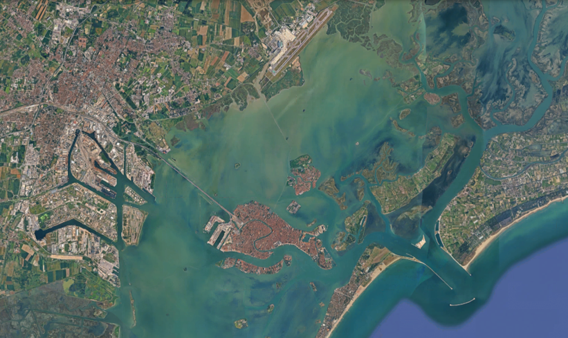
Venice’s car-free transportation network solves some common urban transportation problems but introduces new and different engineering problems to solve. This article will first provide some general historical and geological context for Venice’s water-based infrastructure. It will then analyze how to get to the city and how the people, goods, and services are moved around the city without roads. Afterwards, it will look at what the transportation network does well and what problems they face today. It will conclude with a personal take from the author and some first-hand observations in the city.
Historical & Geological Context
Venice was most likely founded in around 600 A.D., when Italian refugees running from Lombard attacks made it to the islands in the Venice lagoon (Britannica, n.d.). Venice’s lagoons are shallow, averaging around one meter (three feet) depth throughout the entire lagoon (Geography Worlds, n.d.). To build on unstable ground, they drove millions of tree trunks into the muddy and wet ground, which have been holding up the city for centuries (The Archaeologist, 2023). Since the wood was pushed so deep underwater, oxygen could not reach the wood. With no oxygen, the wood could not decay, so instead it went through a process of mineralization, making the wood stronger (The Archaeologist, 2023).
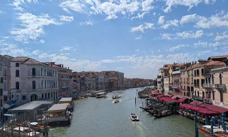
Due to its advantageous position, in the medieval ages, Venice became a major trading port, and one of the greatest seaports in late medieval Europe. The shallow lagoons also served as protection from attacking armies, because invaders did not know the lagoon as well as the Venetians, letting the area thrive more (Britannica, n.d.). Additionally, their shallow lagoons were a big source of income from marine life and birds living there, and from salt pans in the lagoon (Britannica, n.d.). For shipping, the canals were maintained and dug in to make them deeper for boats. Today, Venice’s canals are deeper than the one-meter average depth so boats can go through. They range from 1.5–3 m (3–10 ft) wide for the smaller and secondary canals, and the grand canal is five meters (16 feet) wide (Maddy, 2026). Figure 2 below shows the Grand Canal, the widest canal in Venice.
With canals already reaching almost every part of the city, there was little need for roadways to be built on the island. Today, it is not practical to build roads for cars due to the high amounts of tourism, the effects on the fragile ecosystem, and space required for cars (Britannica, n.d.). The same water-based infrastructure that protected and kept Venice prosperous now must handle 21st century traffic at a much higher capacity.
Getting to Venice
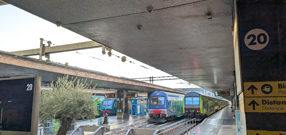
Getting to Venice is similar to getting to most European cities, but it being on a lagoon provides some challenges. The airport is located on the mainland which is about 13 km (8 mi) from the Venice city center (Veneto.info, 2025). The Santa Lucia train station is in the lagoon, close to the city center. The Santa Lucia train station has 16 tracks and has roughly 82,000 people passing through it every day (ItaliaRail, n.d.). Figure 3 shows the Santa Lucia train station. The train goes on the Liberty bridge, which connects Venice to the mainland. There are four different tracks for trains on the Liberty bridge. The Liberty Bridge is visible on the satellite imagery in Figure 1 as well.
Driving
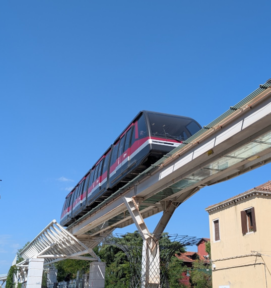
It is also possible to drive to Venice. The Liberty Bridge also has four car lanes, two in each direction. Most of the city is car-free, but there are a few parking lots that people can park in. The parking lots in Venice are about 25–35 euros, but parking in Mestre, which is on the mainland, is about 5-15 euros for the day (Jurga, 2024). If people decide to park in Venice and park in Tronchetto (where the cruise terminal was), they could take The People Mover to go to the city center. The people mover is a land funicular on a monorail which connects Tronchetto to the city center (Veneto.info, 2025).
Cruise Ships
There were cruise ships that used to dock in Venice, but all large cruise ships were banned in 2021 to protect the delicate ecosystem (Miller, 2025). Now, no vessels over 25,000 gross tons or ships longer than around 180 meters (590 feet) can enter the Venetian lagoon (Miller, 2025). Now, large cruise ships arrive in Ravenna, and it takes approximately 3 to 4 hours to get to Venice from Ravenna by train (Miller, 2025).
Getting Around Venice
All modes of transportation within Venice solve the same problem: how do you get around when all you have are water or small alleyways? The short answer is boats and walking. Every trip made in Venice, whether it is a resident going to work or a tourist wandering around, relies on these two methods. There is no single best way to get around, since there are trade-offs between each option, and there are many kinds of boats to ride around. Some are cheaper and take longer or some are more physically exhausting. Understanding how these pieces of transportation work together say a lot about how a car-free city functions day to day.
Walking
Every city in the world includes walking or some accessible alternative in day-to-day transportation. With narrow alleyways, no major roads, lots of bridges, and a maze of a city layout from hundreds of years ago, Venice’s walking experience is different than that of a normal city. Figure 5 shows an example of a narrow alleyway that would be impossible for a car to fit through.

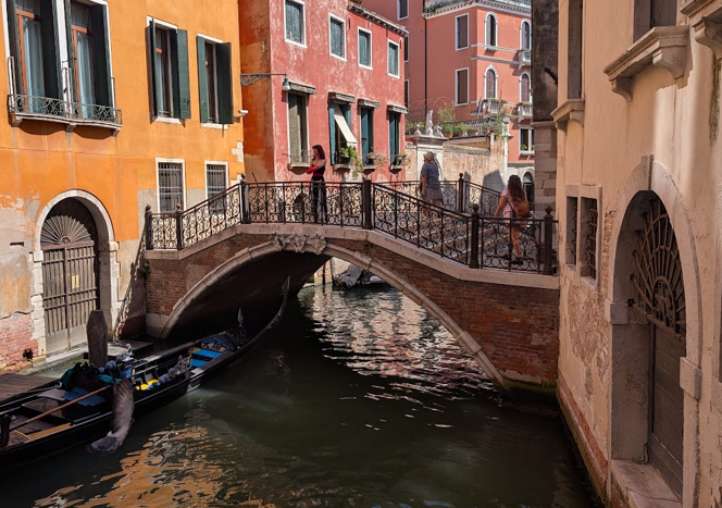
Venice’s small streets with pops of color makes it pleasant to walk in. The side streets are quiet and the water surrounding it makes it scenic. The lack of cars driving makes it feel safer and quieter. Venice’s streets may seem flat as they are right on the water on small lagoons, but the bridges provide a large change of elevation. Figure 6 shows an example of a small neighborhood bridge in Venice. The change of elevation makes walking tiring and makes it harder to transfer items.
Venice’s streets become a maze with not many landmarks to follow. With a confusing street layout, pedestrians begin to follow each other on main paths, walking from one main site to another (Gorrini & Bertini, 2018). Additionally, with so many canals, everyone must cross specific bridges to get across, which causes a lot of people to travel on very similar routes. These two factors work together to keep everyone on a similar path: the confusing layout makes people default to the same path that they have taken before and seen other people take, and the bridges physically force everyone to be on the same route since there are a finite number of bridges. From personal observations, this makes some alleyways to be completely full of pedestrians, but one turn off the main route leads to a completely empty alleyway. Figure 7 displays a heat map showing the crowd flows after the Carnival in 2008. The denser and brighter the lines, the more of a crowd was in that street.
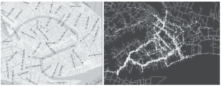
What stands out in Figure 7 is how uneven the distribution is. Only a few amount of routes, mainly the ones connecting major sites together with bridge crossings are bright, while most of the surrounding streets are dark, meaning that they have little foot traffic. This lines up with personal observations of not seeing many pedestrians outside of the main, busy routes. All of the pedestrians get funneled into main routes, because the layout and canal crossings do not leave another choice. During something as busy as the Carnival, this kind of bottle necking leads to high amounts of overcrowding and inconvenience to both tourists and the people living there. Overcrowding could be a large safety issue if too many people are packed into tight alleys and bridges. It is worth keeping in mind that this heat map only reflects on event in 2008, so the exact routes may shift from year to year, but Venice has increased a lot in tourism so it is most likely even more dense today than it was in 2008 (Road Genius, 2024).
Public Waterbuses
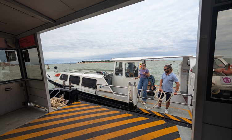
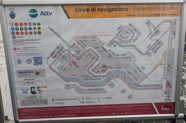
Since Venice does not have any roads big enough for buses to go on, they have water buses. Venice has the Vaporetti, which are larger water buses with capacity for 210-220 passengers, and the Motoscafi, which are smaller water buses with the capacity for 154 passengers. The Vaporetto only runs route 1 and 2, and the Motoscafo runs all the other routes (“Vaporetto Explained”, n.d.). Below shows a typical Motoscafi in Figure 8. All 26 lines are run by the ACTV, which is the main public transportation corporation in Venice that controls all the waterbuses. A map displaying all of the ACTV lines is shown in Figure 9 below. Every year, they carry more than 190 million passengers. They have approximately 160 boats and 150 floating pontoons (“Vaporetto Explained”, n.d.).
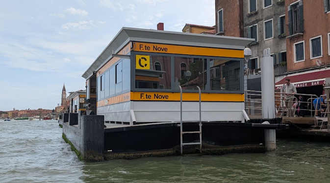
The ACTV public transportation network has over 70 different boat stops that service the 26 lines. Each stop is a rectangular metal building with a ceiling floating on a dock. Some of the boat stops are split into many different docks if there are a lot of boats that stop there. For instance, the Piazzale Roma boat stop is split into five docks for the seven different lines that stop there (Capua et al., 2012). The floating docks are convenient, because they do not take much space on the land. Since it rains a lot in Venice, it is convenient that all the docks have roofs. Figure 10 below shows a typical Venice boat dock for the ACTV.
Gondolas
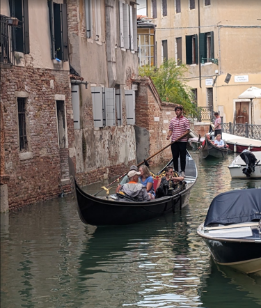
Gondolas are what most people think when they think of transportation of Venice. Historically, they were used in Venice. In the 17th and 18th centuries, there were an estimated 8,000 to 10,000 gondolas in the canals of Venice (Newman, 2026). Today, there are only about 400 in active service (Newman, 2026). They are primarily used for tourism in Venice due to its cost and it being slow. There is an official city service rate for gondolas at 90 euros for a 30-minute tour in the daytime (from 9:00 to 19:00), and 110 euros for a 35-minute nighttime tour (from 19:00 to 4:00) (“Rates, times and stations Gondola Service”, 2023). Any other times are calculated in proportion to the times listed above. They can also only board up to five people (“Rates, times and stations Gondola Service”, 2023). Figure 11 below shows a gondolier driving their gondola.
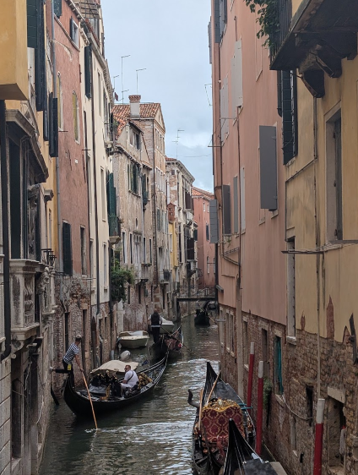
Even though they are inconvenient and expensive, the way that gondolas are engineered to work is interesting and works well for Venice’s tight canals. Venetian rowing for gondolas actually work a lot differently than other rowing styles. There was a study shown that a gondolier uses the same amount energy to transport three people with the weight of the boat compared to walking that distance (Rowing techniques, n.d.). They use a single oar, which is good for saving space to go through the narrow canals. The gondoliers do not change the side that the oar is on (Rowing techniques, n.d.). They paddle on the right side, and to keep it straight, the boat naturally leans to the right and the paddling technique helps fix the direction (Rowing techniques, n.d.). Figure 12 below shows gondolas going through a tight canal.
Water Taxis
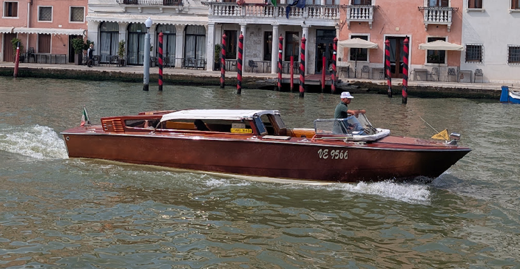
Water taxis are similar to car taxis found in other cities. Water taxis are privately owned motorboats that drive people around Venice. They get people as close to their destination as possible through the canals. A lot of the time, people still have to walk to their destination due to it not being on the canal. They are usually roughly 40-100 euros from the train station, and 140-160 euros from the airport (Herald, n.d.). They are much more expensive than the water buses, but they are convenient. Just like buses versus taxis in other cities. Figure 13 below shows a common Venetian water taxi.
Traghetti
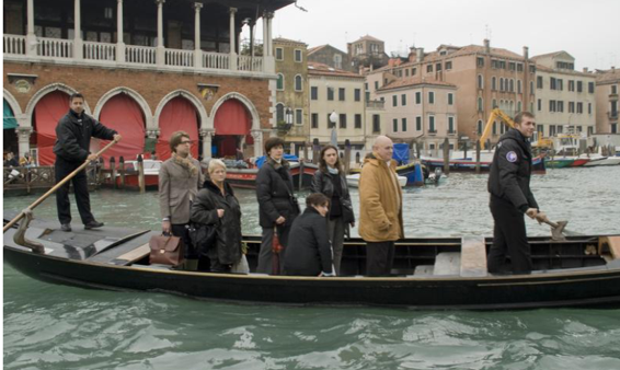
Traghetti are one of the only forms of transportation used in Venice without a motor that is used not for tourism. It looks very similar to a Venetian gondola, but they are used for a different reason: to cross the Grand Canal. They can carry a maximum of about 20 people, and are convenient to cross the Grand Canal, because there are only four bridges spanning the Grand Canal (Capua et al., 2012). They are cheap, about two euros to cross the canal (Capua et al., 2012). Figure 14 below shows an image of a traghetto used in Venice.
Getting Goods and Services Around
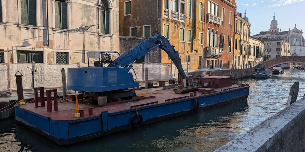
With no cars or trucks in the historical district, getting goods and services around Venice is a difficult challenge that Venetians must conquer. Most goods are delivered by boat and there are carts that bring the items to their final destination. Figure 15 shows that they even have cranes on boats! These solve some common urban delivery problems but introduce completely new challenges that have interesting solutions.
Deliveries
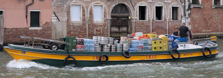
With no roads, Venice has to get deliveries by boats instead of delivery trucks. These short and long delivery boats deliver everything to homes and businesses that need anything. From the mainland, trucks deliver food to warehouses and distribution centers. From there, workers transfer the goods onto cargo boats designed specifically for Venice’s canals. They have flat bottoms, so they can go through shallow waterways easily (Herald, n.d.). In Venice, drivers have to worry less about street parking and traffic, like they do in other cities. Figure 16 below shows a cargo boat making deliveries.
After the cargo boats get as close as they can to their destination, they load all the goods needed for that location on carts. The delivery workers or customers then move the carts to their final destination. Venice is flat in general, but almost all the bridges in Venice have stairs which makes moving carts difficult. To solve this problem, seen from personal observations, the carts are specifically designed to go upstairs. They have extra wheels on the cart to help them roll upstairs easier and instead of carrying it, they are still rolling it. These solutions may help the people moving goods, but it is still difficult and physically exhausting.
Figure 17 below shows delivery workers with a heavily loaded cart, made for moving many packages at once. They are preparing to carry the cart up the stairs. The two small orange wheels at the front go onto the first step, while the large wheels stay on the ground and roll up afterwards. Since the bottom wheels are larger, they can climb each step easier and avoid obstacles.
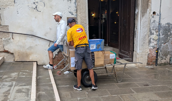
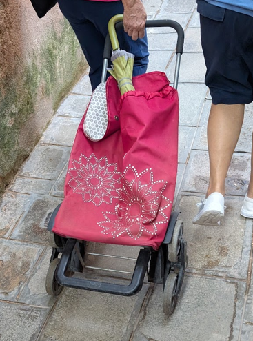
Figure 18 below shows a local resident’s shopping cart. The three-wheel design is a smart design choice, because when they go up the stairs, the top wheel catches the next step, letting the cart go up much easier.
Trash Collection
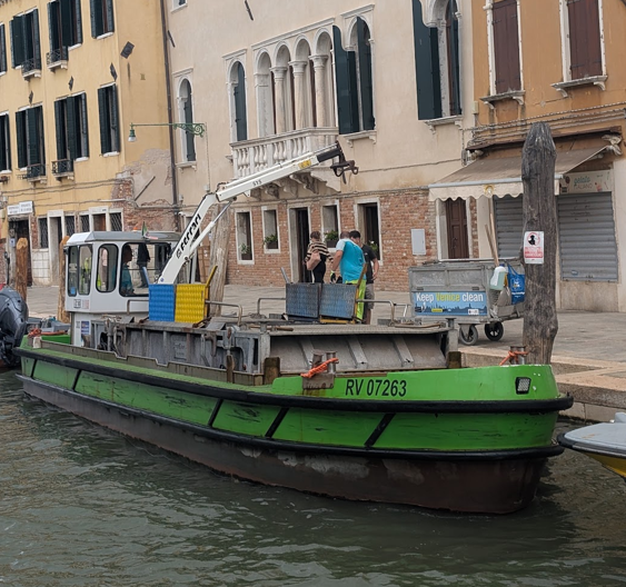
With millions of tourists visiting every year, rats living in the city, and hungry seagulls stalking for food, trash collection is important in Venice. Trash collection in Venice follows similarly to the deliveries but in reverse. The trash collectors start collecting the trash. They go door to door to collect waste in the trash carts. Monday, Wednesday, and Friday, they collect paper, and on Tuesdays, Thursdays, and Saturdays, they collect glass, plastic, and cans. They collect general waste every day (C40 Cities, n.d.). They have to split the days, because they have specific compactors for paper versus other recyclables (C40 Cities, n.d.). After that, they take them to the boat to get compacted and deal with the trash on the mainland. Figure 19 shows a typical trash boat used in Venice.
Problems Solved and Given by Venice’s Transportation
Not having cars in Venice’s historic center solves a lot of urban transportation problems that a lot of other cities struggle with. It benefits people overall with health benefits like walking more, less noise, and less overall stress from cars. In Italy, road deaths were at 51 per million inhabitants (EU Parliament, 2025). Having no cars dramatically decreases the number of accidents happening in the city. The grade separation between the boats and where pedestrians walk considerably help with that. From personal observation, there was less of a fear to be hit by cars day to day.
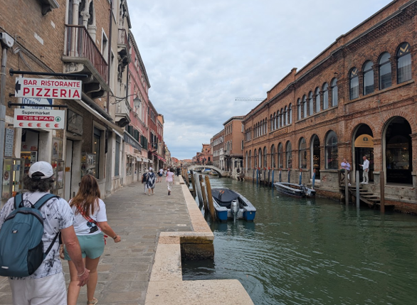
Additionally, researchers have identified 11 pathways that link transportation and a negative health outcome. They are “physical inactivity, air pollution, motor vehicle crashes, heat, stress, community severance, social exclusion, greenhouse gases, contamination, and electromagnetic fields” (Glazener et al., 2022). A large amount of these negative health outcomes are solved when there are no cars in the central area. One thing that is still present in Venice is air pollution. As of 2019, there was more air pollution in Venice than there is on the mainland (Butler, 2019). In Venice, 44% of the pollution is from the engines of the boats (Butler, 2019). Additionally, from personal observation, the public buses and cargo boats still run on diesel. Venice is doing something about it: large cruise ships were removed from Venice in 2021, which have decreased the amount of air pollutants produced by cruise ships by 80% (Transport and Environment, 2023). Venice is also generally quieter in the historic center. At least 20% of Europeans are exposed to road traffic noises that are loud enough to cause adverse health effects (Arregi et al., 2024). From personal observation, the canals in Venice were much quieter than the surrounding cities. Figure 20 shows a typical quiet canal.
Tourism
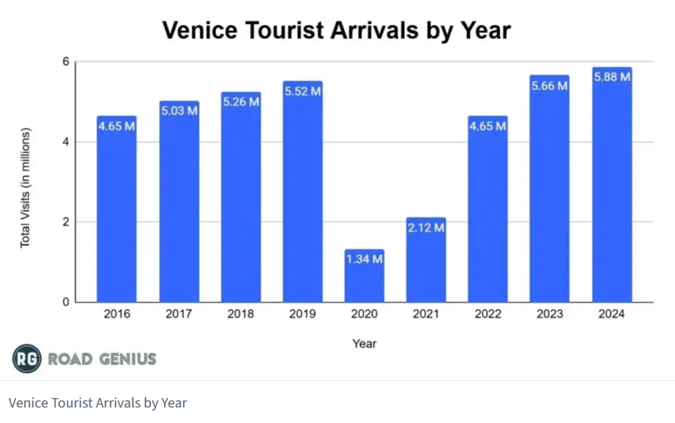
Tourism has a big effect on Venice, both positive and negative. Venice has a daily number of visitors of 60,000-70,000 people, and that has a huge impact on Venice’s transportation network and overall life. More than two-thirds of the total income and at least half of the jobs are a product of tourism, so it is crucial for Venice’s economy (Capua et al., 2012). In the case of transportation, most of Venice’s traffic patterns are different than cities of its size. The traffic is more determined by the visitors visiting Venice than normal day-to-day commute to work and leisurely night (Prosdocimi et al., 2024). A lot of locals change when they do their activities to combat against the time that tourists are visiting (Prosdocimi et al., 2024). The large cruise ships being banned in 2021 did not really affect the number of tourists arriving per year, but COVID-19 did temporarily influence it. The number of tourists visiting Venice surpassed to how they were before the cruise ban and before COVID-19. Figure 21 shows a bar graph showing the number of tourists arriving to Venice each year. This rebound shows that despite efforts to manage the effects of tourism, Venice’s economy and day-to-day are tied to the effects of tourism, for better or for worse.
Personal Take
For me, Venice has been a very pleasant city to visit for their transportation, but usually, the public transportation took around the same time as just walking. The walking was calming, and it was a nice change to not be constantly having to worry about getting run over like I did in Rome. The narrow and winding alleyways always gave me somewhere new to explore, and my favorite parts were when I took a turn into a narrow alley and ended up somewhere I did not know existed. The other transportation options were also pleasant for the most part.
The high speed rail took me directly to the historic downtown from Rome, which was very convenient. The vaporetti were in general nice to use but were inconvenient at times. They ran consistently, and it was mostly a smooth ride. Sometimes, they would get crowded, and I had to stand in the middle for over twenty minutes, which was not the most pleasant experience. It is also hard to tell which boat is what line, because there is just a small sign explaining it, so I did get on the wrong bus while I was there in Venice.
I do think that Venice’s modes of transportation partly limit their economic prosperity in the historic center, due to modern shipping logistics not being able to work there as well as other cities. Due to that, a lot of locals are moving away from the historic center if they do not work in tourism (S. Croce, September 9, 2026). Instead, a lot of them are moving to the mainland, where there is more space and not overran by tourism. I do think that it feels wrong that a lot of locals have to leave Venice and that is partly due to their transportation network which was made hundreds of years ago.
As someone who is from Seattle, which has one of the largest ferry networks in the USA, Venice is an interesting city to visit. Seattle has water taxis, which are like the vaporetti, just on a much smaller scale with them only having two lines, while Venice has over twenty lines. I did not get to ride or interact with the Venetian car ferries, but I imagine that they are similar to the Seattle car ferries. I personally really enjoy whenever I get to be on the water on a form of public transportation. I think that one thing that we can learn from Venice is to depend on boats for passenger travel more, and I think that Seattle is the perfect place to do it. Seattle has the Puget Sound connected to Lake Union connected to Lake Washington. If Seattle sets up terminals along those areas for passenger travel, I think that it would be a useful addition for passenger travel.
I think if we emulated something like what Venice did, we would have fewer traffic related fatalities and a higher quality of life for those living in Seattle. Parts of Lake Union are unreachable by train and bus takes a while to go around the lake, so if there were public boats in the lake, it would help people with their day-to-day. I do not think that Seattle will reach a similar fate that Venice reached if Seattle made this network. It may increase tourism to Seattle because it is unique, but I do not think it would reach the same level like it has in Venice. Venice has been historically known for being on the water and having many movies and books written about it. Seattle also has a lot more space than Venice has, and it already has much more people living there, so I personally do not think that Seattle will have the same fate that Venice has.
Conclusion
Venice’s transportation network is proof that a city can function and thrive without cars. Its geography forced an unusual solution centuries ago, and the consequences are still there today with different kinds of transportation methods. In many ways, this system solves problems that cars can never fix, like having fewer traffic accidents, quieter streets, and more pleasant walks. Venice’s transportation infrastructure also creates its own set of challenges. Deliveries require a lot more handling and physical labor to get goods around, and gas-powered boats still pollute the air and water. To top it off, the sheer volume of tourism places a strain on a system that was not built for the number of tourists that it sees today.
Venice is worth studying not because it has a perfect solution, but because it shows what is possible for a city to have without cars. Having spent four days walking, riding vaporetti through the canals, and watching the city function, I came away with appreciation for how much thought and engineering goes into making a car-free city work like this on a large scale. Cities like Seattle can take lessons from Venice about using more of their water for local transportation instead of regional travel. Venice is a great engineering example of how successful a city could be without having cars.
References
The Archaeologist. (2023, November 7). The surprising foundations of Venice. https://www.thearchaeologist.org/blog/the-surprising-foundations-of-venice
Arregi, A., Vegas, O., Lertxundi, A., Silva, A., Ferreira, I., Bereziartua, A., Cruz, M. T., & Lertxundi, N. (2024, July). Road traffic noise exposure and its impact on health: Evidence from animal and human studies-chronic stress, inflammation, and oxidative stress as key components of the complex downstream pathway underlying noise-induced non-auditory health effects. Environmental science and pollution research international. https://pmc.ncbi.nlm.nih.gov/articles/PMC11297122/
Butler, J. (2019, August 25). Electric boats exempt from Venice restrictions. Plugboats. https://plugboats.com/electric-boats-exempt-from-venice-restrictions/
Capua, M., Guyette, J., Hetherman, B., & Hock, L. (2012). The impact of tourism on the venice public transportation system. Worcester: Worcester Polytechnic Institute.
Europe’s luxury cruise ships emit as much toxic sulphur as 1BN cars -…. Transport and Environment. (2023, June 15). https://www.transportenvironment.org/articles/europes-luxury-cruise-ships-emit-as-much-toxic-sulphur-as-1bn-cars-study
Geography of Venice: Location, Terrain, Climate & Natural Features | Geography Worlds. (n.d.). https://geographyworlds.com/blog/venice-city-geography/
Glazener, A., Wylie, J., van Waas, W., & Khreis, H. (2022, June). The impacts of car-free days and events on the Environment and Human Health. Current environmental health reports. https://pmc.ncbi.nlm.nih.gov/articles/PMC8831014/
Google Earth. (n.d.). Google Earth. https://earth.google.com/web/
Gorrini, A., & Bertini, V. (2018). Walkability assessment and tourism cities: the case of Venice. International Journal of Tourism Cities, 4(3), 355-368.
Herald, D. (n.d.). How Venice gets its groceries by boat. DHIE. https://www.deccanherald.com/dhie/social-studies/2026/07/30/how-venice-gets-its-groceries-by-boat
Home ACTV (ENG). ACTV. (n.d.). https://actv.avmspa.it/en/content/home-actv-eng
Jurga. (2024, December 15). How to visit Venice by car (+tips for best parking in Venice). Full Suitcase – Travel Guides & Itineraries. https://fullsuitcase.com/venice-by-car/
Maddy. (2026, May 27). How deep are Venice’s canals? depths of the Grand Canal + More. Venice Travel Tips. https://www.venicetraveltips.com/how-deep-are-venice-canals/
Miller, T. (2025, November 18). Venice’s cruise ship ban and the rise of Ravenna Port. Italy Awaits Travel. https://www.italyawaitstravel.com/blog/venice-cruise-ship-ban-ravenna-port
New waste collection system in Venice – C40 cities. C40 Cities. (n.d.). https://www.c40.org/case-studies/new-waste-collection-system-in-venice/
Newman, P. (2026, March 4). Venetian gondolas: History, Facts & Must-know tips. European Waterways. https://www.europeanwaterways.com/blog/everything-you-need-to-know-about-venetian–gondolas/
Prosdocimi, I., Masiol, M., & Tattara, G. (2024, February 26). Air pollution in Venice and in its mainland: A first assessment of air quality control policies – environmental and ecological statistics. SpringerLink. https://link.springer.com/article/10.1007/s10651-024-00602-0
Rates, times and stations Gondola Service. Comune.venezia.it. (2023, April 20). https://www.comune.venezia.it/it/content/servizio-gondola
Road death statistics in the EU (infographic) | topics | european parliament. EU Parliament . (n.d.). https://www.europarl.europa.eu/topics/en/article/20190410STO36615/road-death-statistics-in-the-eu-infographic
ROWING TECHNIQUE. Boats – rowing technique. (n.d.). https://www.venetia.it/boats/voga_eng.htm
Scomparin, I. (2026, July 30). How Venice water taxis work: Everything you need to know before you ride. Tour Leader Venice. https://tourleadervenice.com/how-venice-water-taxis-work-everything-you-need-to-know-before-you-ride/
Vaporetto Explained. Vaporetto explained. (n.d.). https://everything.explained.today/Vaporetto/
Veneto.info. (2025, September 23). Transport in Venice: How to get around by Public Transport. Veneto. https://www.veneto.info/en/venice/transport-venice/
Venezia Santa Lucia Train Station Guide. ItaliaRail. (n.d.). https://www.italiarail.com/train-station/venezia-santa-lucia-train-station
Venice tourism statistics – how many tourists visit? (2024). Road Genius. (2024). https://roadgenius.com/statistics/tourism/italy/venice/
Venice | Italy, history, population, & facts | britannica. Britannica. (n.d.). https://www.britannica.com/place/Venice