
How Roads in Ancient Rome Were Constructed
by Romain Laurent-Michel
September, 2026
Introduction
“All roads lead to Rome” is one of the first sayings that comes to mind when talking about Rome. The importance of roads in the empire cannot be overstated; from Egypt to Britain, roads were a key feature of the empire. They were built in different environments for different purposes, using different techniques and materials. This legacy continues today in Rome, from its modern asphalt to its medieval cobblestones, and in the ancient stone roads this article focuses on.
During this study abroad trip to Rome, I wanted to choose a project that let me explore many different parts of Rome while learning about an engineering topic that touches on many fields of information. Initially, I considered researching the materials and supply lines of Rome’s different monuments. Eventually, I decided on the roads of ancient Rome, a key part of the city’s culture and history.
Studying Roman roads let me explore in depth a part of the city we did not cover in class. It also taught me a lot about the different aspects of Rome: its geology, economy, military, and the tools and techniques available to the Romans. Focusing on the Via Appia (Figure 1) allowed me to narrow the broad scope of “the roads of the Roman Empire” to a practical level.
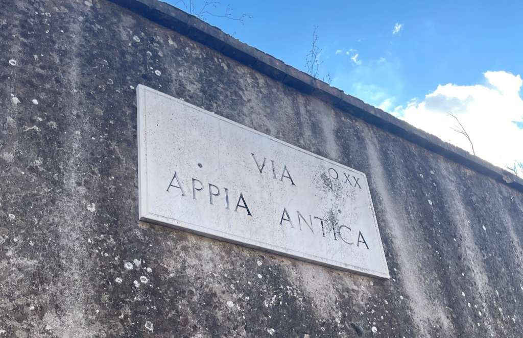
Since the first paved road in Rome, the Via Appia, built in 312 BC by Appius Claudius Caecus, the Romans continued to build roads until the fall of the Western Empire. The Romans built an impressive 300,000 kilometers of roads (de Soto et al., 2025), with about 80,500 kilometers paved with stone (Kumar A, 2026). This large road network (see Figure 2) raises two main questions: why did the Romans build so many roads, and how did they construct them?
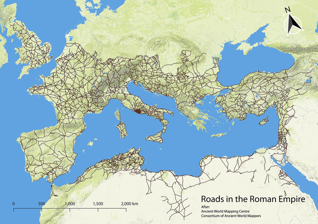
(Mellangoose, 2025)
Why Make Roads?
As they are today, roads were part of everyday life in ancient times. People used them to commute, go shopping, and do many other day-to-day activities. However, building a paved long-distance road required a massive investment of resources, money, and workforce.
The Romans wanted to expand their influence and control over resources; these large roads allowed for the movement of military resources. However, the military alone was not enough to justify these roads economically. The roads enabled faster transport of goods, specifically agricultural surplus, which provided huge benefits to the Romans (Berechman, 2003).
The economic benefits of these roads were noticeable for both the empire and its people. Improving land transportation not only connected inland regions but also allowed merchants who could not afford expensive and impractical boats to transport agricultural surplus to other regions. The movement of food helped Rome address supply shortages and reduce the effects of famines, keeping the people fed and maintaining the empire (Berechman, 2003).
To keep building large projects and keep imperial coffers full, Rome enforced tolls across ten customs zones. The empire would situate itself at choke points, such as bridges, to assess the value of transiting goods and collect approximately a 2-2.5% tax (Berechman, 2003).
Along these large roads, the Romans built rest stops, mansiones, for people, mules, and horses. Mansiones served as inns where travelers could rest themselves and their mules or horses. Frequent rest stops allowed longer trips, connecting trade between distant locations and enabling missions that would have been possible only by boat before.
However, Rome was an expansionist war nation, where times of peace were rare. The military was the primary reason for the constant expansion of roads. The roads served to quickly move large numbers of soldiers and maintain a continuous supply of resources to fuel Rome’s expansion.
During the Roman Republic, when Rome was still a small region in Italy, the creation of the Via Appia served as a crucial supply line from Rome to the southern front of the Samnite Wars. The road enabled Rome to conquer and maintain control over the southern regions, laying the groundwork for Rome’s future expansion (Laurence, 1999).
Construction of Roads
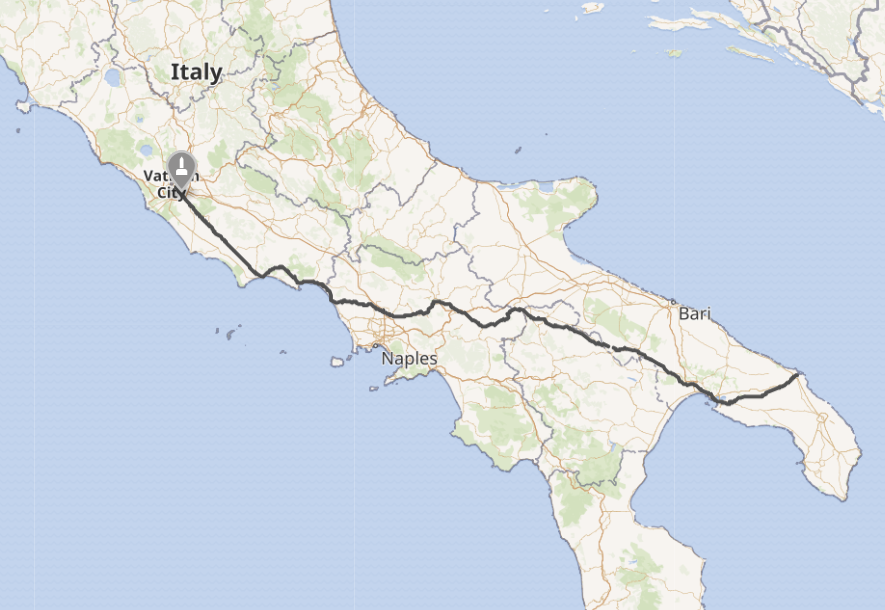
The construction of roads in ancient times was an immense undertaking that required expertise in planning and construction. Rome was a civilization that endured for a long time across diverse landscapes and geographical contexts. So this paper focuses on the Via Appia (see Figure 3) and the roads around Rome. The roads were constructed in multiple steps, surveys would plan the route, and then several phases of construction would begin simultaneously.
Planning
Regardless of the time or place, careful planning is essential to road construction. In ancient Rome, surveyors began by examining the land, identifying obstacles, and determining if it was possible to build through them. They also considered the terrain’s gradient to establish a practical route with manageable inclines and effective drainage (Berechman, 2003).
Roman roads, particularly the Via Appia (Figure 4), are known for their straight routes. This alignment was not accidental, it required careful planning and precise measurement. Why, then, did the Romans make their roads so straight?
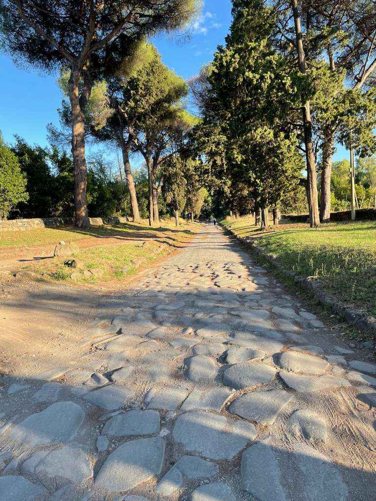
(Photograph taken by author)
Before answering this question, it is important to clarify that not all Roman roads were straight. The surrounding environment played a key role in determining a road’s design. When a mountain or marsh obstructed the proposed route, it was often more practical to curve the road around the obstacle than to drain the marsh or dig a tunnel through the mountain (Berechman, 2003).
Even without large hills, rivers, or marshes, the terrain still posed significant challenges to building a straight road. They had to level or smooth hills and depressions to maintain a manageable gradient. Engineers also had to build bridges across valleys and rivers (Berechman, 2003). Given these challenges, why did the Romans construct straight roads?
There are two main reasons to make a road as straight as possible. The first and most obvious is geometry: the shortest distance between two points is a straight line between them. A shorter travel distance reduces time spent in transit, improving the efficiency of Rome’s economy and military (Berechman, 2003).
Second, having a straight road across relatively uniform terrain eases construction; with a straight road, it is possible to design one segment and repeat it without variation. This reduces construction time and enables low-skilled workers to repeat a pattern without direct management (Berechman, 2003).
Construction
In ancient Rome, there were no vehicles to transport heavy materials such as stone or gravel, importing materials was the greatest expense in projects of the day (Berechman, 2003). When it comes to road construction, materials were collected from nearby quarries or the land directly around the road.
To minimize transportation costs, the Romans relied on locally available materials. The region around Rome contained abundant volcanic stone, particularly basalt, which was durable and workable, making it well suited for paving roads.
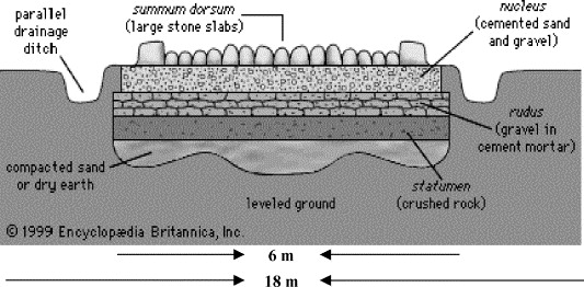
Once surveyors had established the route, construction proceeded in several stages. Each successive layer contributed to the road’s stability, durability, and resistance to water damage (see Figure 5).
(The Encyclopedia Britannica, 2000)
After the planning, workers marked the road’s width then excavated the roadway using shovels and pickaxes. They removed loose soil until they reached firm ground or bedrock, while also digging drainage ditches along the sides. They then leveled the exposed surface with surveying tools such as the chorobates and compacted it to form a stable foundation. It was important to prepare the ground so that the layers above would not shift or collapse, creating a pothole.
Because the excavated ground still contained small depressions and irregularities, workers spread a leveling course of sand or lime mortar, depending on the available resources. They raked, smoothed, and compacted this material into a bed approximately 3 inches thick. This produced a more even surface for the layers above to rest upon (Berechman, 2003).
The first layer was the statumen, a foundation of stones packed closely together by stonecutters. Mortar or clay could be used to fill gaps and hold the stones in place. By spreading the weight of traffic across a broad base, the statumen enhanced stability and reduced irregularities (Pachta & Stefanidou, 2018).
Above the statumen was the rudus, a layer approximately 9 inches thick made of coarse gravel, broken stone, and mortar. This mixture acted as a concrete-like material, compacted to lock into the layers above and below and merge the road layers into a unified structure rather than a stack of loose materials (Berechman, 2003).
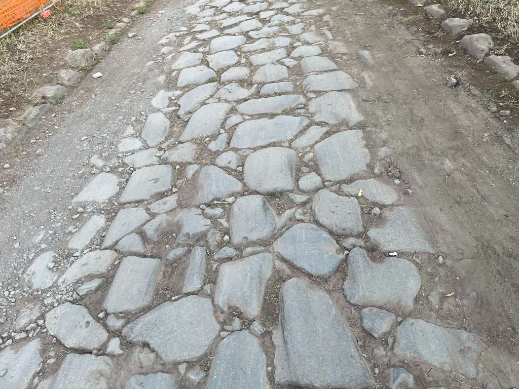
The nucleus formed the upper base of the road. It consisted of gravel or sand mixed with hot lime and was repeatedly compacted with rollers or rammers. The layer was thicker near the center, reaching up to 18 inches, compared with about 12 inches near the curbs (Berechman, 2003). This raised center, or crown, created a slight slope that directed rainwater toward the sides of the road rather than allowing it to collect on the road (See Figure 6).
(Photograph taken by author)
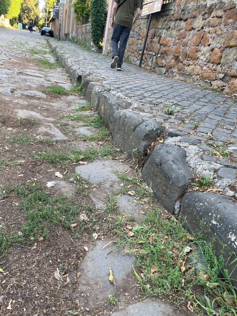
Important roads such as the Via Appia received a paved surface and side stones (Figure 7) that defined and supported the roadway. The final paving stones were local durable stone, such as basalt in the case of the Via Appia. Stonecutters shaped and fitted these paving stones closely together, while gravel was used to fill the gaps between them. The finished surface had to be firm enough to resist heavy traffic but carefully graded so that water flowed toward the gutters and drainage ditches.
(Photograph taken by author)
Road Drainage
A major component of Rome’s roads was their drainage system; ditches or gutters running parallel to the road were used to divert rainwater away from the road, keeping it from becoming muddy or swampy. They were built to the depth of the solid foundation, about 3-4 ft deep. The ditch served not only as drainage but also as a quarry for road materials, providing gravel and dirt for surfacing (Berechman, 2003).
Milestones
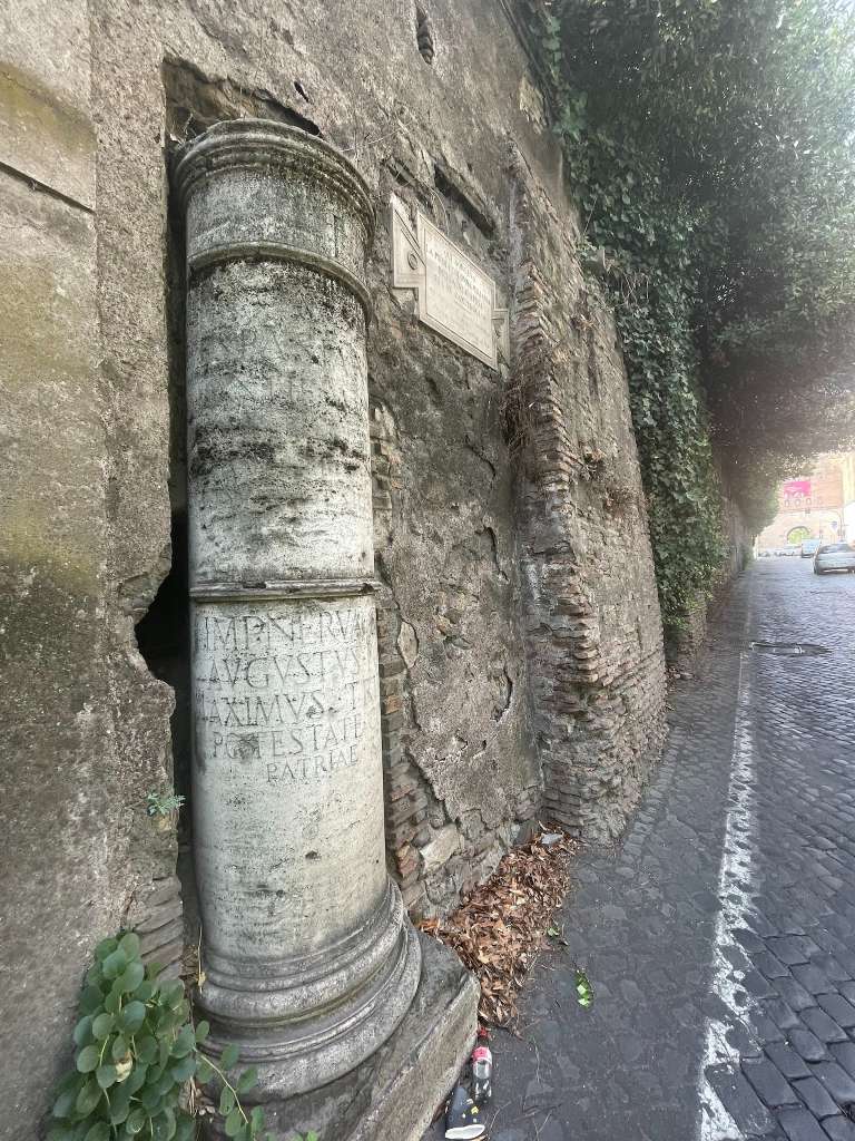
From the late Republic through the imperial period, mile markers (Figure 8), or miliaria, were placed every thousand passus, approximately 1,480 meters, and indicated distances along the route.They typically took the form of cylindrical columns made from marble, granite, or other locally available stone.
In addition to miliaria, the Romans used milestones that indicated the distance to Rome from points across the empire. The miliarium aureum, likely erected by Augustus around 20 BC, reinforced the idea that Rome stood at the center of the empire (Wilson, 2019).
(Photograph taken by author)
Tools
Tools were an important part of a Roman engineer’s equipment for planning and constructing roads. Of all the tools used by the Romans, two stand out as crucial to road development and planning. The Groma and the chorobates: the effectiveness of these tools is apparent in the achievements they enabled.
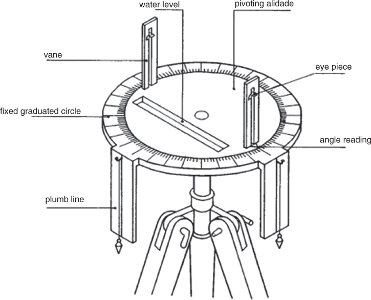
The groma was a tool for aligning points and finding right angles; it was widely used by the Romans. However, they were not the first to have a similar tool: the dioptra (see Figure 9), an angle-measuring device described by Hero, a Greek mathematician, was used to apply math to astronomy, surveying, and tunnel boring.
The groma was a simple yet effective tool (see Figure 10). It consisted of a vertical staff set into the ground, with a rotating cross at the top; the surveyor could then rotate the cross to align hanging plumb lines to find right angles or to ensure distant points were in line (Adam, 2025).
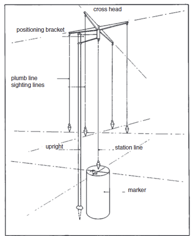
(Adam, 2025)
The chorobates was an important tool for a Roman surveyor; it looked like a wooden bench with vertical legs and a channel on top that served as a water level. There were reference lines on the side aligned with plumb lines. These features allowed the Romans to identify the terrain’s angle. (see Figure 11). Vitruvius suggests that this instrument was about 6 meters long, or 20 feet, which, if true, would be impressive. The difficulty of using an instrument of that size, and the fact that wood bends and warps with changing temperatures and humidity, suggest that a smaller device of more reasonable proportions was also used (Adam, 2025).
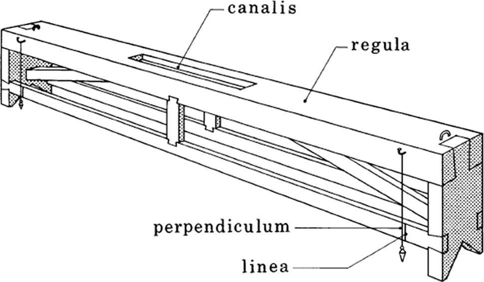
(Adam, 2025)
It, along with the Groma, was one of two tools used in conjunction to achieve an impressive result. The groma helped surveyors find straight lines and right angles, while the chorbates helped measure incline and level the terrain. Used together, Roman engineers could establish the direction, drainage, and gradient of roads that would last millennia.
The Appian Way
The Appian Way, known as the Queen of Roads, is one of Italy’s earliest paved roads. In 312 BC, Appius Claudius Caecus built the Appian Way as a strategic response to regional wars (Laurence, 1999). Initially connecting Rome to Capua, the road was later extended several times until it reached the heel of Italy.
As the Via Appia extended southward, its role expanded beyond its original military purpose. In addition to supporting the movement of soldiers and supplies, it connected Rome with other cities and agricultural regions, enabling merchants to transport more goods to and from the capital.
The construction of the Via Appia was a massive undertaking. According to rough estimates by Berechman (2003), completing the route from Rome to Capua in five years required between 25,000 and 36,000 masons, stonecutters, laborers, and enslaved people each month. This workforce built approximately three kilometers of road per month.
The Via Appia Antica is still in use today, with people using all forms of transportation on it, from bicycles to cars (see Figure 12). For all sorts of reasons, for all intents and purposes it still functions as a normal road; houses, shops, and restaurants can still be found along its length.
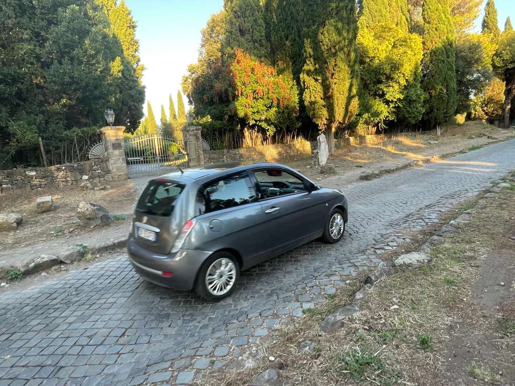
(Photograph taken by author)
Administration and Maintenance
As is true today, roads were costly, labor-intensive infrastructure to maintain. During the Republican period, responsibility for roads rested with censors and special curators. Censors sometimes financed roads themselves, while landowners could fund roads that crossed their property. Fines and tolls imposed on unauthorized travelers provided another source of revenue. As the road network expanded, provincial governors assumed responsibility for funding both its construction and maintenance (Berechman, 2003).
During the imperial period, emperors assumed greater responsibility for roads and often subsidized their construction. This support also functioned as imperial propaganda by demonstrating the emperor’s benevolence, wealth, and power to local authorities (Berechman, 2003). Road construction was a major source of employment in Rome. As noted earlier, approximately 30,000 free and enslaved laborers participated in building the Via Appia.
At many sites, Roman roads contain ruts consisting of one or two parallel grooves worn into the basalt paving stones (Figure 13). Some formed gradually as wagon wheels repeatedly followed the same path, and their depth ranges from 6 to 30 cm. In wet or mountainous terrain, workers sometimes carved ruts deliberately to help prevent carts and horses from slipping (Berechman, 2003).
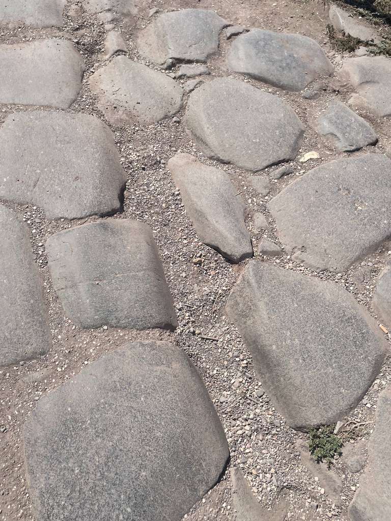
(Photograph taken by author)
After the collapse of the Western Roman Empire, the road network lost its funding, so it slowly fell into disuse and disrepair. Many sections of the roads were completely abandoned, allowing nature to take over and erase them from history, while others leave only traces of their existence in property lines. Others, such as the Via Appia, continued to be used, being repaved and restored throughout history. Figure 14 shows old basalt stones patched with more modern sampietrini tiles, commonly used in Rome since the 16th century.
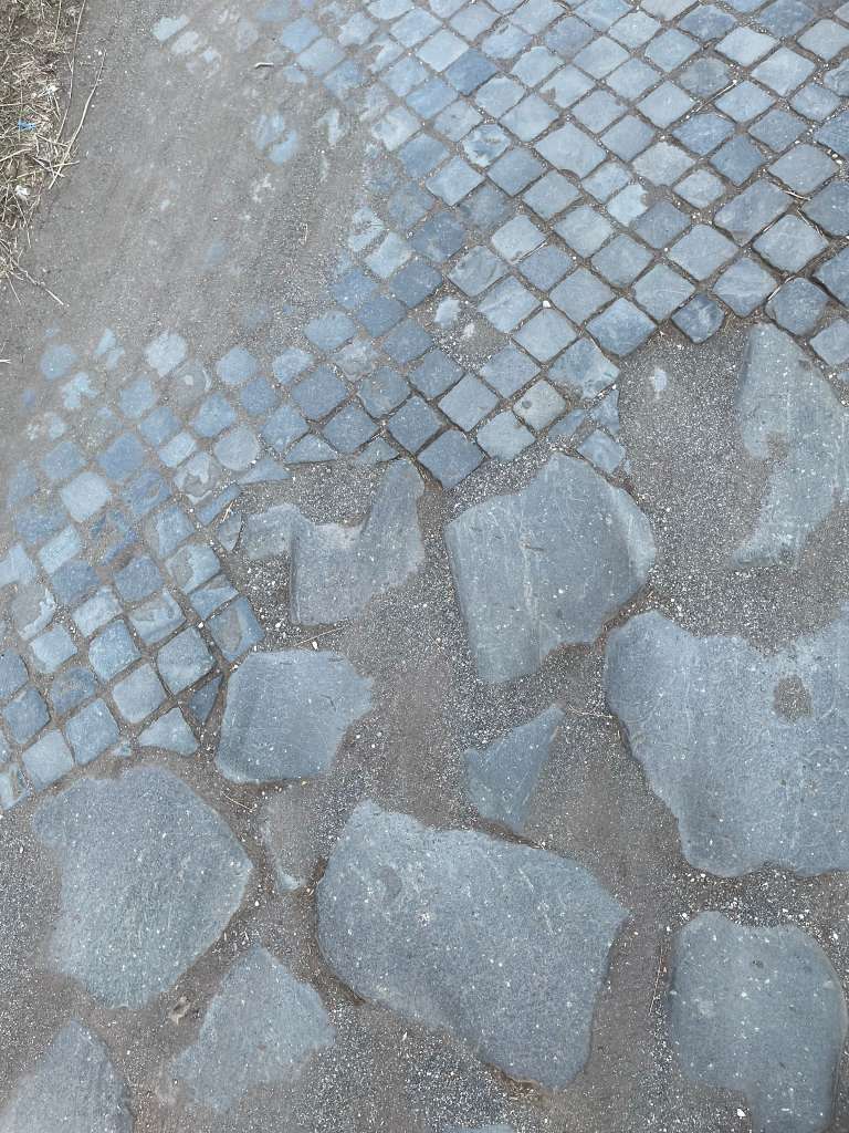
(Photograph taken by author)
Personal Thoughts
Returning to the questions asked at the beginning of this report, why did the Romans build roads, and how did they construct them? My time in Rome and the research I conducted led me to several conclusions. First, Roman roads served as a foundation of the empire by increasing connectivity, supporting the military, and fostering an economy that spanned the Mediterranean.
Second, I gained a greater appreciation for the skill and logistical coordination required for ancient construction. Operating tools such as the groma and chorobates demanded technical expertise, while building the roads required enormous amounts of labor. Roman roads represent a feat of ambition and engineering that I will continue to admire long after my time in Rome.
Conslusion
The Roman road network was one of the Roman Empire’s great engineering achievements. Major routes such as the Via Appia supported the rapid movement of troops, supplies, information, and commercial goods, helping Rome expand, govern, and prosper. Constructing these roads demanded careful planning, extensive labor, large quantities of materials, and considerable skill in adapting to varied environments. Their layered foundations, effective drainage systems, and continued maintenance help explain why some sections have survived for more than two thousand years.
The Via Appia clearly shows the history and importance of Roman roads. It was built to connect the Roman Republic with distant regions and support its territorial growth. Its military and economic value made it a model for roads throughout the empire, earning it the title “Queen of Roads.” Today, the Via Appia (Figure 15) continues to serve the people of Rome and attract visitors from around the world.
The major roads of ancient Rome remain marvels of construction and engineering. The resourcefulness required to build them and the skill needed to plan and survey their routes produced an achievement whose effects remain visible more than two thousand years later. Roman roads changed the course of history by helping the empire expand its borders and supporting trade on an unprecedented scale in the region.
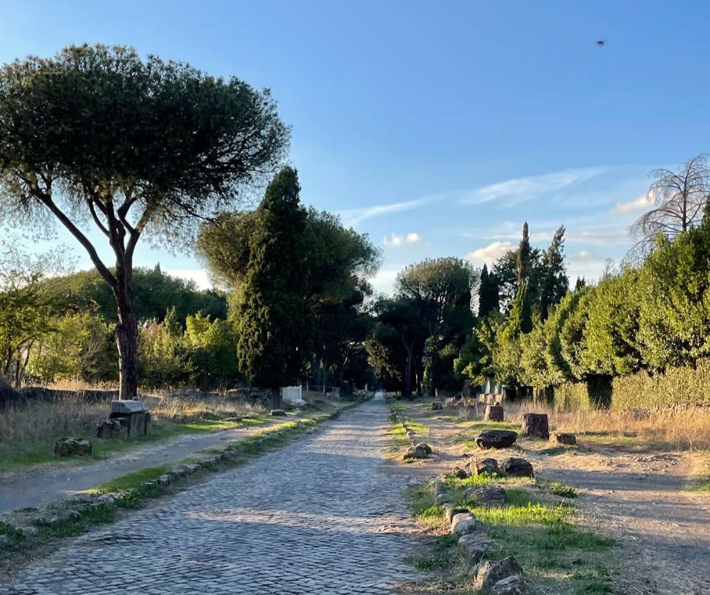
(Photograph taken by author)
References
Adam, J.-P. (2025). Roman building: Materials and techniques (A. Mathews, Trans.; 2nd ed.). Routledge. https://doi.org/10.4324/9780429322600
Berechman, J. (2003). Transportation-economic aspects of Roman highway development: The case of Via Appia. Transportation Research Part A: Policy and Practice, 37(5), 453–478. https://doi.org/10.1016/S0965-8564(02)00056-3
de Soto, P., Pažout, A., Brughmans, T., Peter Bjerregaard Vahlstrup, Álvaro Auir, Toon Bongers, Jens Emil Bødstrup Christoffersen, Maël Crépy, Mathias Holland Johansen, Joseph Lewis, Louis Manière, Michele Rüzgar Massa, Louise Matilde Harreby Møller, Bérangère Redon, Giuseppina Renda, Hamdi Şahin, Adéla Sobotková, Amanda Leighton Spatzek, Philip Verhagen & Barbora Weissova. (2025). Itiner-e: A high-resolution dataset of roads of the Roman Empire. Scientific Data, 12, Article 1731. https://doi.org/10.1038/s41597-025-06140-z
Kumar, A. (2026, September 9). Roman road system. In Encyclopedia Britannica. https://www.britannica.com/technology/Roman-road-system
Laurence, R. (1999). The roads of Roman Italy: Mobility and cultural change. Routledge. https://www.perlego.com/book/1711668/the-roads-of-roman-italy-mobility-and-cultural-change-pdf
Mellangoose. (2025). Roads in the Roman Empire [Map Illustration]. Wikimedia Commons. https://commons.wikimedia.org/wiki/File:Roads_in_the_Roman_Empire.jpg

Pachta, V., & Stefanidou, M. (2018). Technology of multilayer mortars applied in ancient floor mosaic substrates. Journal of Archaeological Science: Reports, 20, 683–691. https://doi.org/10.1016/j.jasrep.2018.06.018
Vitruvius Pollio. (1914). The ten books on architecture (M. H. Morgan, Trans.). Harvard University Press. https://lccn.loc.gov/14019299
Wikimedia Foundation. (n.d.). [Map of the Appian Way] [Map]. Retrieved September 24, 2026, from https://en.wikipedia.org/w/index.php?title=Appian_Way&oldid=1369247153
Wilson, M. (2019). The Roman road system around the Mediterranean. In [editor initials and surname] (Ed.), Lexham geographic commentary on Acts through Revelation (pp. 175–194). Lexham Press. https://www.sevenchurches.org/wp-content/uploads/2020/04/Roman-Road-System-Mediterranean-LGC-Wilson.pdf